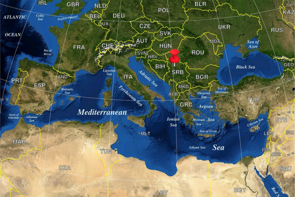
General information about Serbia

Area: 88.499 km² (with Kosovo); 77.474 km² (without Kosovo)
Population: 6.8 million (without Kosovo); 8.8 million (with Kosovo)
Capital: Belgrade
Official language: Serbian
International phone code: +381
Time zone: CET
Currency: Serbian dinar (1 din. ∼ 118 €, 1 din. ∼ 96 $)
Climate: moderate-continental
Airports in Serbia are:
- In Belgrade Nikola Tesla
- In Nis Constantine the Great
- In Kosovo Pristina
- Serbia is well connected with bus lines and there are lines from most European capitals.
- At the main bus station "BAS" in Belgrade, there are most international lines and lines between major cities in Serbia.
- From the bus station "Lasta" which is in the immediate vicinity, there are also international lines, as well as bus lines for most places in Serbia.
- In Serbia, railway traffic is also functioning
- Close to the main bus station "BAS" in Belgrade, there is the Main Railway Station.
The climate in Serbia is a moderate-continental climate. All four seasons are expressed.
Average temperatures:
Mean annual air temperature is 11 ° C. The coldest months are December and January, and the hottest July and August.
The warmest part of the year is summer with a mean seasonal temperature of 21 ° C to 22 ° C. In recent years, summers are getting warmer and the daily temperatures can be very high, reaching over 35 ° C.
The average winter temperature in the higher regions is lower than 0 ° C, while in Belgrade it is 2.4 ° C.
During spring and autumn, the average seasonal temperature is between 11 ° C and 12 ° C.
Analyzing by months, July is the warmest month with a mean monthly temperature between 20 ° C and 23 ° C, while in the mountains the average July temperature is 13 ° C to 17 ° C. The coldest month is January with a mean air temperature from 0 ° C to 1 ° C, and in the mountains to -4.5 ° C.
Precipitation:
Most of Serbia has a continental rainfall regime, with larger quantities in the warmer half of the year, except in the southwestern regions where the highest precipitation is measured in autumn. The rainiest month is June and the least rainfall months are February and October. The appearance of the snow cover is characteristic of the cooler part of the year from November to March, and the largest number of days with snow is in January.
Winds:
In the warmer part of the year prevailing winds from the northwest and west. During the colder part of the year dominated by the eastern and southeast winds (košava in Serbian). In the mountainous regions of the southwest of Serbia, prevailing winds from the southwest.
Geographical determinants that significantly affect the weather and climate of Serbia are the Alps, the Mediterranean Sea, the Genoa Bay, the Pannonian Plain, the Morava Valley, the Carpathians, and the Rhodope Mountains, as well as the hilly mountain part with basins and highlands. The prevailing meridional position of the basin river and the flatland landscape in the north of the country allows deep penetration of polar air masses to the south.
In Serbia there are 5 national parks:
- Djerdap Gorge (Iron Gate)
- Kopaonik
- Fruska Gora
- Tara mountain
- Sara mountain
There are numerous special nature reserves, as areas with specific natural features that represent preserved, unique, rare and special entities, protected by law.
Special nature reserves are: Bagremara, Brzan Morava, Upper Danube, Goc, Deliblato Sands, Zasavica, Jelasnica Gorge, Jerma, Karadjordjevo, Tresnjica Gorge, Kovilj-Petrovaradin marshes, Kraljevac, Ludas Lake, The Obed swamp, The pasture of Velika Droplja, Selevenj pustare, Slano Kopovo, The Imperial swamp (Carska bara), Dry Mountain (Suva panina), Titel Hill and Uvac.
Major river flows are:
- The Danube which flows through Serbia in the length of 588 km
- Sava
- Tisa
- Drina
- Great Morava
Relief:
The northern part of the earth occupies the plain, and in the southern parts are hills and mountains.
The highest peak: Midzor peak (2.169 m) at Stara planina in Serbia, Djeravica peak at Accursed Mountains in Kosovo (2.656 m).
The lowest point: The mouth of the Timok in the Danube (28 m)
The largest lake: Djerdap Lake (163 km²)
The longest river: Dunav (588 km)
Mountains:
In geomorphological terms, Serbia is mostly a mountainous country, both in terms of age, the way of origin, geological structure, directions, and forms of relief. The mountains are very diverse.
By the way of origin, the mountains are:
- Rodop (old boulders mountains, are located on the left and right sides of the South and the Great Morava, such as Besna Kobila, Dukat, Cemernik, Kukavica, Vidojevic, Jastrebac, and others),
- Carpathian-Balkan (young mountain ranges, occupy the eastern part of Serbia: Homolje, Beljanica, Kucaj, Miroc, Deli Jovan, Rtanj, Ozren, Devica, Suva, Stara planina)
- Dinaric (they consist of several mountain units, young mountain ranges that are more difficult to hike, belong to them are: Tara, Zlatibor, Zlatar, Golija, Kopaonik, Goc, Avala, Kosmaj, Bukulja, Rudnik, Povlen, Maljen, Cer, and others).
The most visited mountains by tourists are Zlatibor, Kopaonik, Divcibare plateau, Old Mountain, Tara, Fruska Gora, Zlatar, Golija, Rtanj, Dry Mountain.