If you are wondering about things to do at the Tara National Park, we will tell you that this mountain offers numerous opportunities for an active, interesting and, relaxing holiday.
Tara National Park covers almost the entire mountain's surface, which certainly belongs to the most beautiful Serbian vacation destinations. Coniferous forests are Tara's trademark and make it the most wooded mountain in Serbia and the region. The wealth of natural resources on this mountain will be a real blessing during your stay. It is one of the favorite destinations for lovers of nature and active vacations.
Accommodation on Tara is very diverse and you can find it in numerous villages in these areas.
Tara is located in the western part of Serbia and belongs to the inner chain of the Dinarides (Dinaric Alps). It is 50 km long, 22 km wide, and has an average altitude of 1200 meters. Its highest peak is Kozji rid (1591 m).
It has rich and diverse tourist values: ecologically preserved natural environment, mountainous terrain with moderate altitude, suitable grounds for winter and summer activities, beneficial climate, Drina with artificial lake Perućac. Because of all this, Tara is one of the most attractive regions in Serbia, and in many ways unique in Europe and the world. Tara Mountain is both a summer and winter destination, and Kaluđerske Bare and Mitrovac are two major visitor centers.
As much as 80% of the National Park area is covered by mixed forests of spruce, fir and beech. Out of over 1000 different plants, about 20 are endemic in nature, the most famous among them is Pancic Spruce, the symbol of Tara - a relic of the Tertiary and a Balkan endemic that survived The Great Ice Age in very limited habitats in the middle flow of the Drina River.
Here are the 8 best suggestions for things to do in the Tara National Park. The proposals are mostly related to spring and summertime.
1) Choose a hiking tour where you will visit the most beautiful viewpoints of Tara
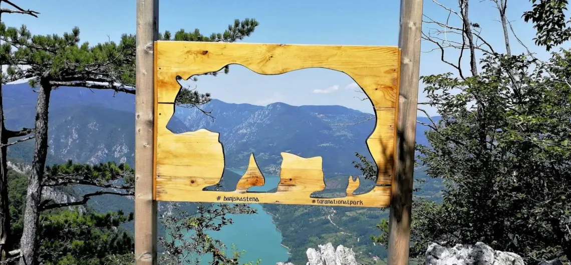
There are numerous and beautiful viewpoints on Tara. The most visited are Banjska Stena and Bilješka Stena, then Crnjeskovo, Sjenic, and Osluša, from where views are fantastic.
Banjska Stena is visited by more and more tourists, from where is a wonderful view of the impressive Drina Canyon. You can reach the viewpoint from Mitrovac by a footpath that is 7 km long, with a slight ascent. You can also take the car at a distance of about 1 km from the viewpoint, then after about 15 minutes walk along the macadam and forest road, you will reach Banjska Stena.
The second most visited viewpoint is Crnjeskovo, which can be reached by footpath about 6 km in length from the center of Kaludjerske Bare.
There are over 290 km marked hiking trails on Tara. According to your capabilities and preferences, you can choose trails from easy, moderate, and difficult category.
The starting points for hiking are:
- Kaludjerske Bare – a plateau at the restaurant Jeremicak
- Mitrovac – in front of Tara National Park Visitors Center
- Mountain Zvijezda and Crni vrh (Black peak) – the lodge at Predov krst
- Rasište – a mountain hut (an old school) in the village Sedaljka
Below you can find general characteristics of some hiking trails on Tara.
Easy category – technically not-demanding hiking tours from 5 to 10 km in length:
- Mitrovac – Banjska Stena viewpoint (12 km, 300 m total ascend, duration of the tour 4 h)
- Predov krst – Bilješka Stena viewpoint (12 km, 400 m total ascend, duration of the tour 5 h)
- Kaludjerske Bare – Crnejskovo viewpoint – Jarevac Lake (8.5 km, 400 m total ascend, duration of the tour 5 h)

Moderate category – technically not-demanding hiking tours from 10 to 20 km in length:
- Čehova kuća – Veliki Kraj (13 km, 800 m total ascend, duration of the tour 6 h)
- Kaludjerske Bare – Platno – Jasikovice – Podgrad – Kulina (17 km, 730 m total ascend, duration of the tour 7 h)
- The Raca Monastery – Čokići – Crnjeskovo viewpoint – Sokolarica (16,7 km, 1150 m total ascend, duration of the tour 7 h)
- Rasište Jagoštica – Drlije viewpoint – Bilješka Stena viewpoint (13 km, 700 m total ascend, duration of the tour 6 h)
Difficult category – technically demanding hiking tours from 12 to 25 km in length:
- Predov Krst – Veliki stolac 1675 m – Sjenič viewpoint (20 km, 1100 m total ascend, duration of the tour 8 h)
- Brusnica viewpoints (12 km, 860 m total ascend, duration of the tour 8 h)
There are also hiking trails in the Tara Mountains that belong to long-distance hiking trails, such as the Via Dinarica Green Line and the European long-distance path E7.
Via Dinarica is a tourist product that represents a set of mountaineering and hiking trails connecting natural and cultural sights in the Dinaric area of the Western Balkans.
The Green Line in Serbia, to which Tara belongs, connects mountaineering, hiking, and biking trails in the north-western Dinarides. The total length of the marked trails of Via Dinarica on Tara is about 40 km.
How are the hiking trails marked?
Hiking trails on Tara are marked with 3 types of hiking marks that you should follow: white point in the red circle, red and white stripes and yellow signposts at the beginning of the paths and at crossroads.

European long-distance path E7 is marked with yellow point in the red circle, red-yellow stripes and yellow signposts at the beginning of the trails and at crossroads.

Hiking trail Via Dinarica is marked with a white point inside the green circle, green and white stripes, yellow signposts at the beginning of the trails and at crossroads and green signposts.
If you want to go for more demanding hiking tours on Tara, we definitely recommend you to find a hiking guide.
You can let us organize your hiking tour on Tara by filling out the form below.
2) Relax by kayaking tour on the Drina river
What to do in the Tara National Park if it's a hot summer day and you want to be active. Kayaking an emerald Drina is the best way to experience the river, be active without getting too tired.
The Drina river is one of the cleanest rivers in Serbia. In ancient times, the Drina River was called Drinos. Because of the green color of water, people gave it name Zelenika (zeleno=green).
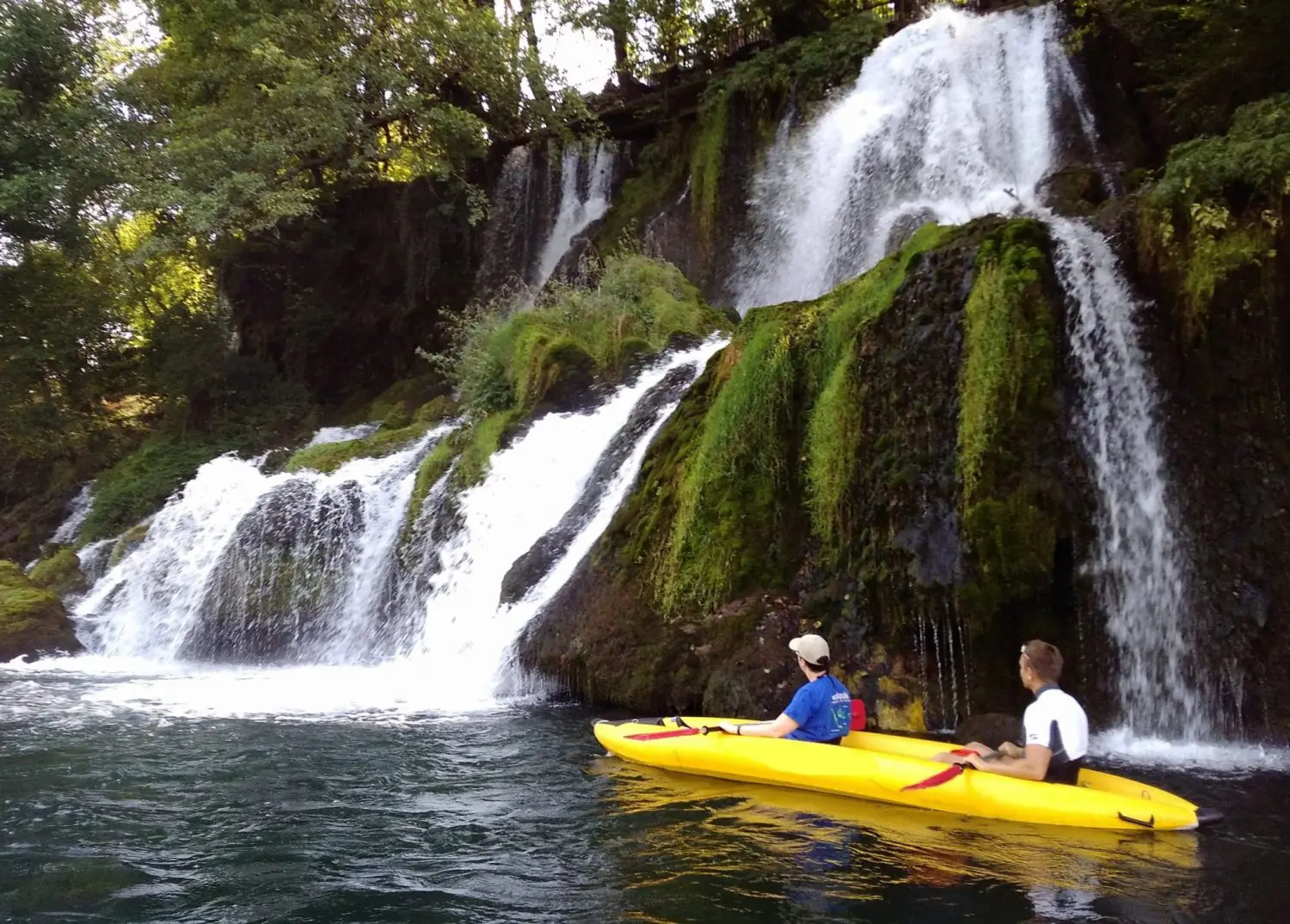
The kayak tour is of a recreational nature. It is performed in stable kayaks and no previous experience is required.
The kayak tour is accompanied by experienced kayak instructors who hold a short paddling course before the tour. Children can also go on the tour. It usually lasts 3 hours with breaks. The start is at the Perućac dam. From the attractions on the tour, you will see the waterfall on the river Vrelo and Little House on the Rock at the Drina river where a tour ends. The tour length is about 15 km.
Small river Vrelo the river is located near Perućac, at the entrance to the Drina canyon. It is 365 meters long, so many say that the Vrelo River is long - one year.
Little house on the Rock at the Drina river is one of the symbol of the town Bajina Bašta. The wooden cottage on an isolated rock in the middle of the Drina River was first built in the summer of 1968. A group of boys made a place to rest on a rock from a nearby collapsed shed to protect themselves from the sun. Swollen Drina took the planks off the rock that fall, but the idea remained. The following year, in the summer of 1969, the first cottage on the rock was built. The material was transported to the rock by boats and kayaks, larger pieces were lowered into the water, then were grabbed, pulled out of the water and brought to the rock. Thus began the story of a rock cottage that lasted for many years.
With its water levels, the Drina flooded, demolished and carried the house several times. However, it is always being repaired or new was built. It is now a tourist attraction that is being visited by more and more tourists. National Geography magazine dedicated a number to it when it was named one of their photos in August 2012 in one of their competitions. This caused a lot of worldwide attention, so on March 9, 2013, the English Daily Mail devoted it article, wondering how the house had resisted the wild nature for so many years. The "Business Insider" ranked in the top 16 strangest houses in the world.
For those who want, kayaking can also be extended to Rogacica. In that case, the length of the kayak tour is 26 km.
Book a kayaking tour on the Drina
3) Spend the day cruising on the impressive Drina Canyon
Cruising the Drina canyon will convince you why this canyon is one of the most beautiful in Europe. It will show you all its beauty. You will hear interesting stories about the Drina canyon, significant historical persons from this area, and other interesting facts.
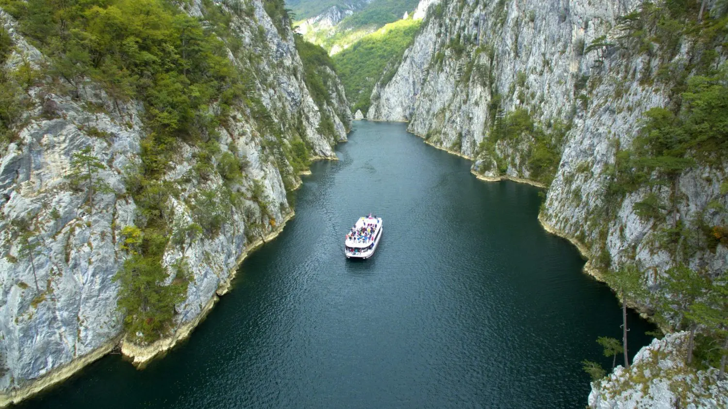
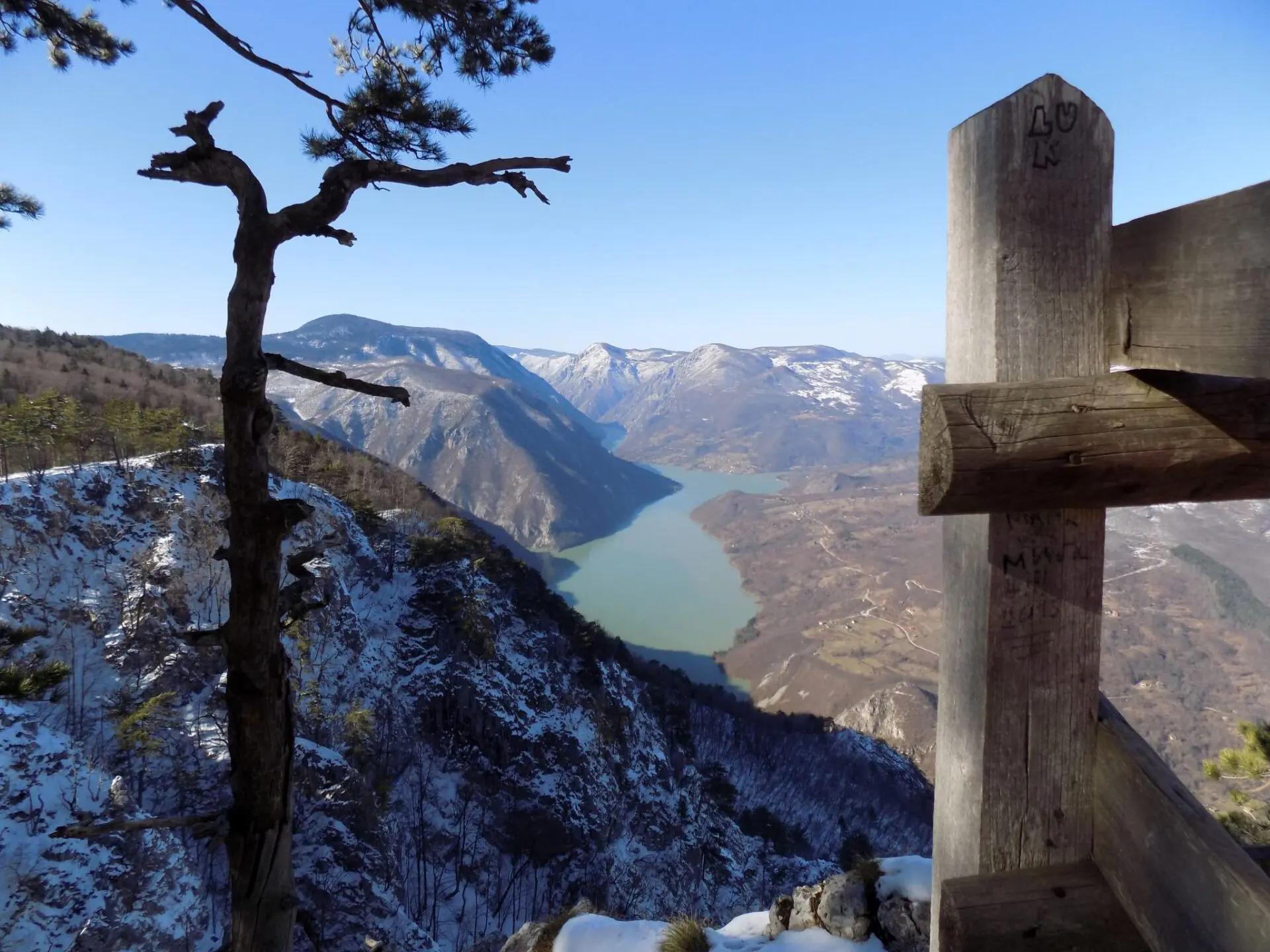
The Drina canyon is the third deepest in the world, after the Colorado Canyon (USA) and the Tara canyon (Montenegro). It is the composite valley type, at the border of Serbia and Bosnia and Herzegovina.
The deepest and most impressive part of the canyon is built by the Drina, climbing the slopes of the Mount Zvijezda, wherein some parts the canyon is deep and up to a thousand meters. The canyon is embedded in massive and rarely layered middle-eastern limestone. The canyon sides are very steep with numerous ponds and scum, covered with forest and shrub vegetation, but often vertical, bare rocky surfaces occur. Apart from Pancic Spruce, there are other rare and relict species such as black hornbeam, and black pine. There are also rain-forests on the edges of the Drina canyon, such as Topli Do, or beech forests in Raca Canyon. Drina Canyon is also a permanent habitat of brown bears and chamois.
Boarding into a ship is at 8 am, at the Sidro Restaurant, located on the right side of the road after the Perućac Dam. It is an all-day tourist excursion, where you will spend about 4 hours on a ship in one direction and in the town of Visegrad for 2 hours.
The cruise is in a large tourist boat that is well equipped. You will have the opportunity to choose a seat and then walk to the deck or to the roof of the boat from where you will see all the power of the Drina River and its magnificent canyon.
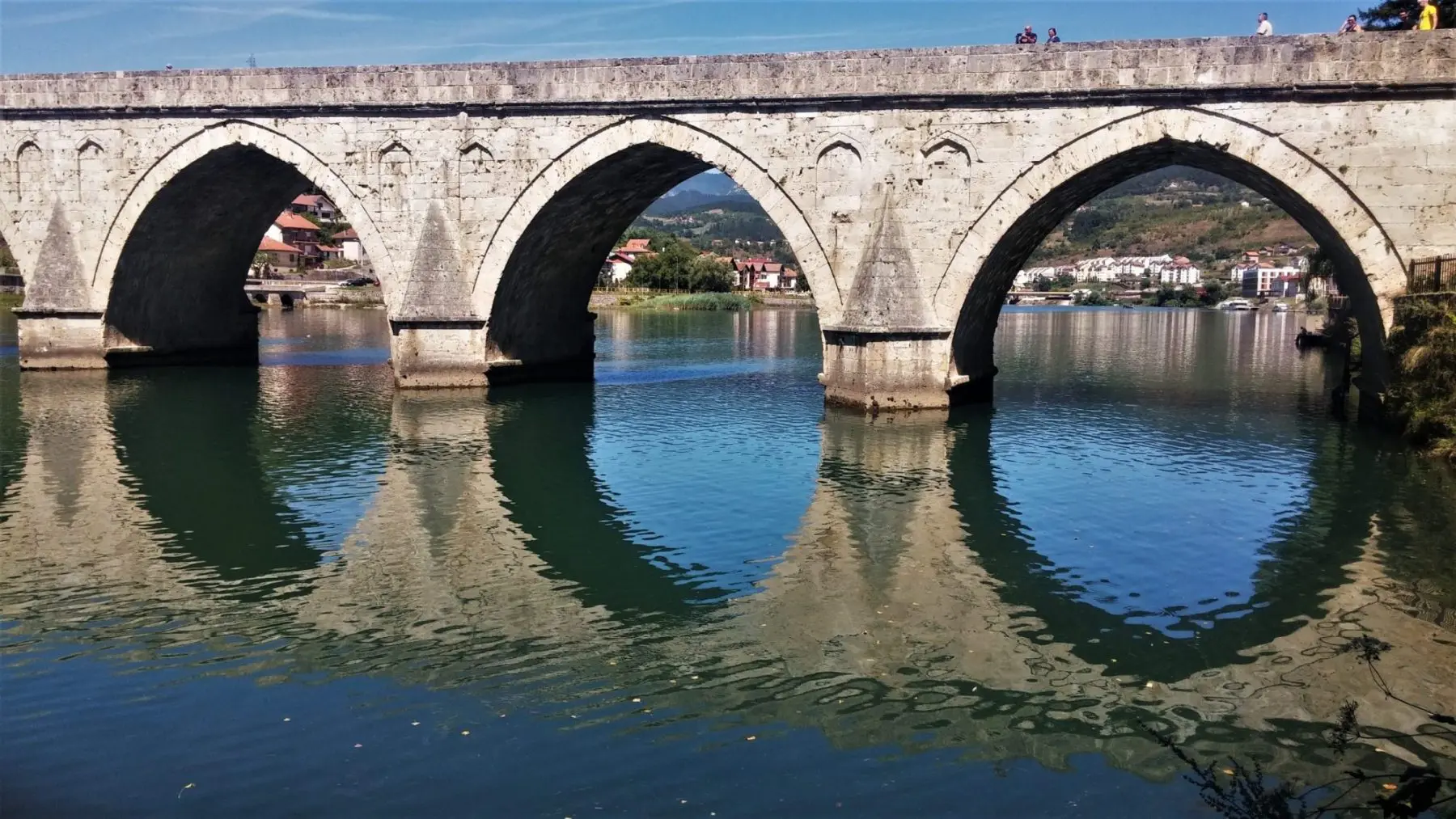
The time spent in Visegrad and Andricgrad will complete this day. You will hear the story of the life of our Nobel Prize winner Ivo Andric and the characters from his most famous novel, "The Bridge on the Drina". As you walk the streets of Visegrad, you get the impression that you can meet them and that they will appear behind a corner at any moment.
In Visegrad, at the point where the mountains that make up the narrow and deep canyons of the Drina split into a vast valley, stands a stone, 500 years old the Mehmet-pasha Sokolovic Bridge with 11 broad-leaved lanes, known by everyone as "The Bridge on the Drina” (na Drini ćuprija). The bridge is about 250 meters long and about 10 meters wide, except in the middle where it is expanded with two terraces, on each side one by one. It is one of the most monumental parts of architecture dating from the 15th to the 19th century. It is the national monument of Bosnia and Herzegovina that is also on the UNESCO list of World Heritage Sites.
Andrićgrad It is is a tourist, cultural, administrative and educational complex located on the peninsula between the Drina and Rzav rivers, some 300 meters from the Bridge on the Drina.
Andricgrad was created as the idea of the famous director Emir Kusturica about a stone medieval town inspired by the work and characters of the Nobel Prize winner Ivo Andric. In architectural terms, the city itself is a mixture of different epochs and styles that have been shifting through the history of this area: The Byzantine style, the Ottoman period, the Renaissance, the classicism. During the walk through the main street-corset, visitors will be able to return to the past which connects two periods - fragments of the Renaissance with the Ottoman period and Byzantium.
After sightseeing of Visegrad, you'll again board into a ship, which arrives back to Perucac at 6.30 pm.
4) Swim and enjoy on Perućac Lake and Zaovine Lake
Zaovine and Perucac Lake with their clean water offer numerous opportunities for a perfect holiday in a mountain ambiance.
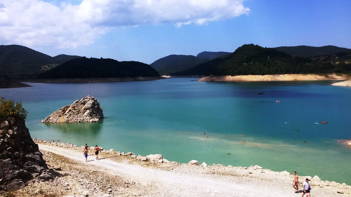
The Perucac Lake is located in the natural bend of the canyon of the Drina River between Bajina Basta and Visegrad. It covers the Tara mountain where the National Park Tara is, representing one of the symbols of nearby Bajina Bašta. It is very suitable for fishing and swimming.
Perućac Lake is artificial, created by blocking the flow of the Drina River for the needs of hydroelectric power plant in Bajina Bašta. The lake is about 60 m deep and 54 m long. The largest part of the lake is located in the Drina canyon, which starts 7 km from the dam. This canyon section is surrounded by a steeply bank bordered by rock cliffs and stone blocks that plunge vertically into the water.
There is a beach on Lake Perucac which has pontoons with swimming pools for children. The swimming area is surrounded by buoys, with lifeguards on the shore and a lifeboat on the water constantly present. There are also showers, slides, and jumping boards. It is possible to rent pedal boats, boats, and kayaks there. There are good restaurants nearby.
Zaovine Lake is one of the most beautiful mountain lakes in Serbia. It is located on Tara Mountain near the village of Zaovine. The water is very clean, with little treatment in the water treatment plants, it is used for drinking.
The lake was formed between 1975 and 1983, when the Beli Rzav stream was blocked by dams near the peak Kik (958 m). At the highest water level, the lake surface is at an altitude of about 880 m. The maximum depth is about 110 meters. The lake is being filled by two streams Konjska Reka and Beli Rzav. The lake is an accumulation of the reversible hydro-power plant "Bajina Bašta" in Perucac with which it is connected by a vertical pipeline.
There are not many beach facilities on the lake, but swimming in the clear water of this mountain lake is a real pleasure. It is located near the dam Lazići and the restaurant Tarsko jezero, which offers a beautiful view of the surroundings and the small lake Spajići. You can leave your car or bike near the beach in a small parking lot.
Zaovine is a forested mountain area in the southwestern part of Tara Mountain. With its 28 hamlets and an area of over 6,000 hectares, it is the most extensive village in the municipality of Bajina Bašta.
Zaovine is famous as the place where the living fossil of the flora – Pancic Spruce was discovered. In the hamlet of Đurići, in 1875, the famous botanist Josif Pančić discovered a new species of conifers, to which he gives the name Pancic Spruce (Picea omorikaHe also mentioned it as an ice beauty. Zaovine Lake and Beli Rzav Canyon are ideal places for fishing (trout, rockfish, chub, barbel), orientation, finding food in nature. There are several viewpoints: Zmajevac, Bela Voda, and, Gavran where you can relax after a walk and enjoy the well-deserved rest in a beautiful ambiance.
5) Be adventurous and dare to go on an exciting canyoning tour
If you want a little more excitement, canyoning tours are one of the great things to do in the National Park Tara. There are several canyons on Tara that you can pass through, but with the presence of a guide and the necessary equipment.
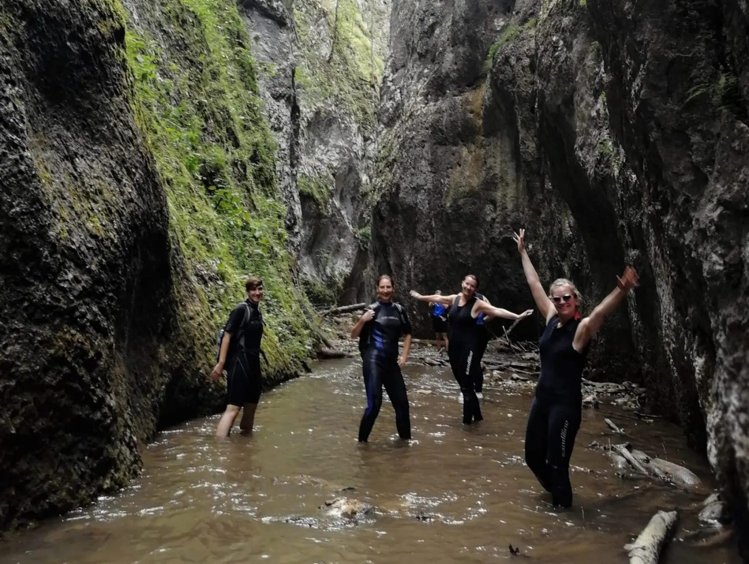
For beginners, the best is Canyon of White RzavIt is a combination of hiking and beautiful canyoning.
The tour starts from the Lazići dam in Zaovine and goes down to the old school in Đurići. From there, you follow the course of the river to enter the canyon after one kilometre. Passing through the canyon last around 4 h. In two positions it is necessary to use the rope and on several places swimming through deep water. After exiting the canyon, continues hiking down the river to the village of Kršanje and further to Kotroman. The tour duration is about 6 hours, where there is an 8 km hike and a 2 km pass through the canyon.
Beli (White) Rzav is an extremely clean river. Its characteristics are the color of the substrate with white stones in the river bed. It springs in the village of Zaovine, on the western slopes of Tara, 23 km long. Thanks to such a river bed, even in summer and the highest temperatures, Beli Rzav is an cold river.
More technically demanding to pass is the canyon of the Raca river.
Passing through the Rača Canyon is a superb experience for the agile and daring. It is a pure canyoning tour with a length of 5.5 km, which is full of interesting details and waterfalls. It starts from Lake Jarevac and ends at the source of Lađevac next to the medieval Rača monastery.
The tour is recommended for physically active persons. It was the final exam for the cadets in the Military Academy of the Kingdom of Yugoslavia. Passing through the canyon lasts about 6 h.
For canyoning tours the necessary equipment is provided – helmets, climbing belts, climbing ropes, and neoprene suits depending on weather conditions.
The canyon is located in the middle course of the river Raca, which springs in the area of Kaludjerske Bare, in the northern part of the Tara mountain, and flows into the Drina near Bajina Basta. The canyon's depth is from 330 to 350 meters. In the central part, the canyon is very narrow, only a few meters wide, and the sides are rocky, polished and completely vertical. On the right side of the canyon, at the exit of the canyon, there is an alkaline-thermal karst springs Ladjevac with a water temperature of 15-18 °C.
6) Choose a bike route through the heart of Tara Mountain and its conifer forests
More than 75 km of cycling routes are available in the Tara National Park starting from tourist centers. Therefore, if you are a fan of mountain biking, you definitely have what to do in the Tara National Park.
The high altitude makes the ride an exceptionally attractive experience.
A tour of medium difficulty is High Tara, 26 km long.
The start of the route is from the Educational Center of the Tara National Park in the village of Sljivovica, located on Kaludjerska Bare-Mitrovac road.
On the wider territory of Racanska Sljivovica there is a natural reserve, rich in forests of fir, spruce, and beech forest. The trail continues across Tarabica brdo, to Beserovacke bare.
You can also get to the viewpoint Osluša. near Mitrovac, overlooking the Drina and Bajina Bašta. The next point is the air spa and weekend village Sokolina, above the Raca canyon. The surroundings of Sokolina, a natural reserve of the Raca Canyon, are a natural habitat of a protected species of brown bear. Nearby are Sokolarica viewpoint, the Ladjevac Thermal Spring and the Raca Monastery. Through Sokolina and Rustina you will reach the last point of the route, Racanska Sljivovica.
This route will take you through the heart of Tara Mountain, where you will see the beauty and diversity of this stunning mountain.
Path: Sljivovica – Tarabica brdo – Grebenski put – Beserovacke bare – Lokvice – Sokolina – Rustine – Sljivovica
The route desription
Length: 26 km
Minimum height: 929 m
Maximum height: 1309 m
Altitude difference: 380 m
Total ascend/descent 1183 m
The route can be ridden in both directions. It requires average physical fitness, but riding in the opposite direction is somewhat harder since the climb starts in the final third of the route. There are no technically demanding sections. There are forest and macadam road surfaces and only a part of the trail surface is asphalt.
You can also ride a bike on the macadam road from Mitrovac to the Banjska Stena viewpoint. Also, by bicycle you can take the asphalt road to Zaovinsko Lake which is about 9 km away from Mitrovac.
The more demanding biking route is Imperial Tara is 42 km long.
Mount Tara is known as the Empress of Serbian mountains. If you want to see it from all angles it is best to take “The Emperor’s Road “. On the 42 km long road stretching from Kaludjerske Bare to Perućac you will be able to see the most beautiful and diverse treasures Tara has to offer. While riding a bike, you can enjoy the view of vast meadows nestled in gentle valleys with towering lone pine trees, dense virgin forests, breathtaking cliffs, and the inevitable Drina River and Perućac Lake. The path leads to numerous lookouts with spectacular views. The route ascends slightly for the first 15 kilometres up to Tankosin Grob (grave) and then the descent begins.
Path: Kaludjerske bare – Dobro polje – Ljuto polje – Tankosin Grob – Mitrovac – Rastiste – Perucac Lake – Perucac
The route desription
Length: 42 km
Minimum height: 236 m above sea level
Maximum height: 1287 m above sea level
Altitude difference: 1051 m
Total ascent: 1737 m
Total descent: 2537 m
Absolute ascent: 800 m
It is possible to cycle in the opposite direction but it requires extreme physical fitness while a cyclist of average fitness can cover the basic route direction. The route takes around eight hours for an average recreational cyclist to ride the whole route. There are no technically demanding sections. The surface of the trail is 65% macadam and the rest of the surface layer consists of asphalt.
If you don't have your own bike, you can rent it at the Tara National Park Visitors Center or at Kaludjerske Bare.
7) Watch the bears from the National Park Observatory
What to do in Tara National Park if you are interested in wildlife watching?
Mountain Tara is known as a natural habitat for brown bears (Ursus arctos) with over 50 individuals in the area.
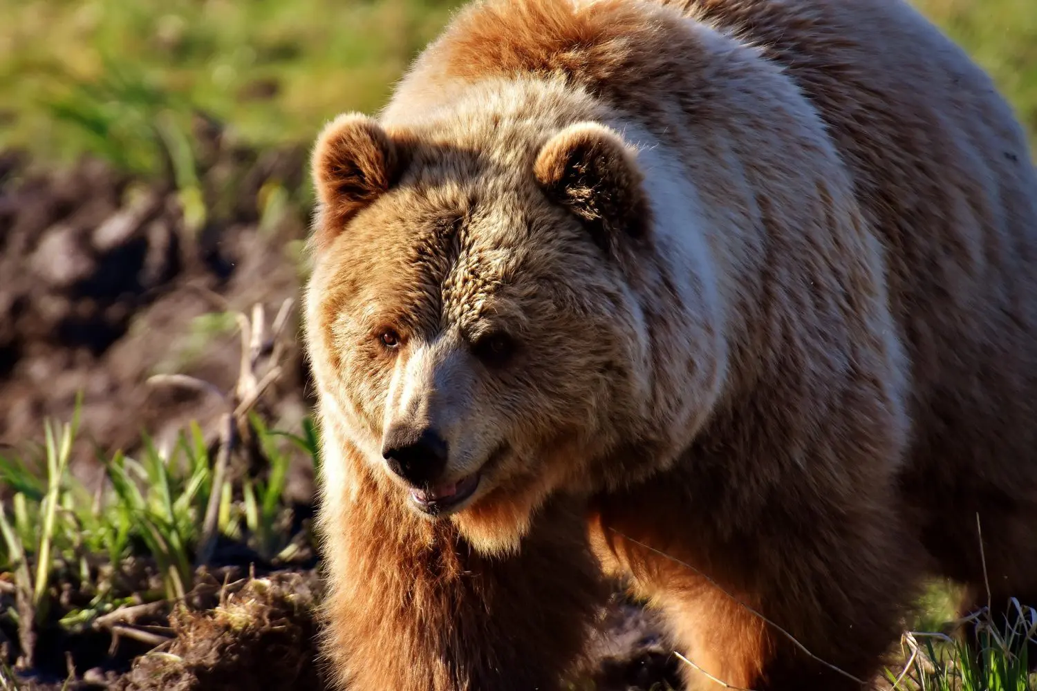
It is not common to meet them because they are afraid of people. When a bear senses the presence of a human, it immediately leaves the area, mostly before we notice it. However, that still can happen. The risk of attack is low. Bears only attack humans if they feel threatened, when they are provoked or when they protect the cubs.
However, if happens that you meet a bear, the most important thing is to stay calm and act responsibly. Do not run away but slowly go back.
The Tara National Park offers the opportunity to see a brown bear in its natural habitat, from safe observation points at feeding sites.
Feeding sites are places where bears are fed at times when experts estimate that there is not enough food in nature. Of the total 4 feeding sites, 2 are available for tourists.
Bears watching tours are being organized for small groups (maximum 3 people) in the presence of the Tara National Park ranger. They can be in the early morning or afternoon lasting for 4-5 hours. Tours are organized between May and October. It is necessary to check the available dates and prices a few days earlier.
After a multimedia presentation on the Tara National Park and a story about the brown bear monitoring program, the off-road rangers drive you deep into the woods. After exiting the vehicle, you'll walk a few hundred meters and get to the observation deck where you'll wait for the appearance of bears in complete peace.
You are very likely to see a bear, but since it is a wild animal, it is not fully guaranteed that you will see it. During earlier tours, the success rate was 60%.
Keep in mind that wild animals have their own way of life, while humans are just trying to get them as close as possible in their natural habitat.
8) Visit cultural and historical monuments and tourist attractions near Tara
What to do in Tara National Park if you are more interested in culture and history? The surroundings of Tara are full of cultural and historical monuments from various historical eras that you can visit.
The most known is the monastery Rača, that has been a source of spirituality and literacy in this part of Serbia since the twelfth century. It was erected by the Serbian King Dragutin in the former Sokolska land. It was repeatedly destroyed and rebuilt from ashes.
Medieval fortress Solotnik (Kulina or Kulingrad) is a fortress near the village of Solotuša, 10 km south of Bajina Basta on the slopes of Tara. It is situated on a stone hill that steeply descends into the Solotusa River.
There is not much historical data on the construction, but it is assumed that the fortress was erected in the Middle Ages to provide a road linking Uzice City and Visegrad. In its immediate surroundings there are remains of settlements from the time of the Celts and Romans. Today it is mostly in ruins, of which the rampart of a rectangular base with the rest of the entrance was held.
In Perucac and Rasiste there are Stećci Medieval Tombstone Graveyards that are on the UNESCO World Heritage List.
Mramorje or Bagruša is a medieval necropolis of stećak tombstones, located in Perućac and one of the most preserved necropolises in the area. The necropolis was formed in the fourteenth century and had about 200 tombstones, made of hard limestone, the largest specimens reaching a length of 2 meters, with a width and height of almost 1 meter. Later sources record the number of 122 monuments, while, according to the latest figures, there are 93.
As you can see, there are numerous opportunities in Tara National Park for one fulfilled vacation. We believe we inspired you to for its exploring.


Comments